St Petersburg airport map
You can find on this page the St Petersburg airports map to print and to download in PDF. The St Petersburg airport map presents terminals and gates of the international airport of St Petersburg in Russia.
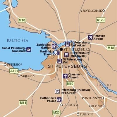
St Petersburg airports map
The St Petersburg airports map shows all the airports around St Petersburg. This airports map of St Petersburg will allow you to determine which airport you will used to leave St Petersburg in Russia. The St Petersburg airports map is downloadable in PDF, printable and free.
St Petersburg is served by Pulkovo International Airport as its mentioned in St Petersburg airports map, and by three smaller commercial and cargo airports in the suburbs. Rzhevka Airport is one of the Russia Airports located in St Petersburg, its IATA code is RVH, while its ICAO code is ULSS and ICAO Code (4 letter airport codes).
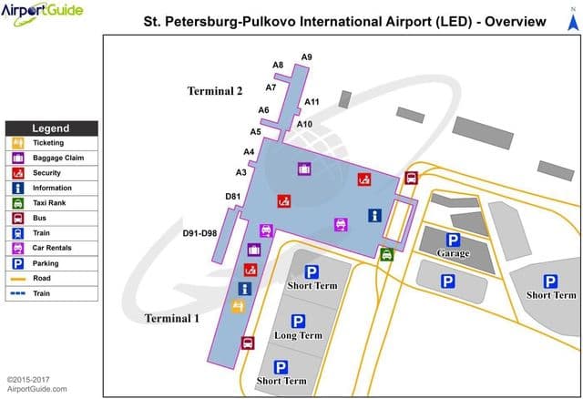
St Petersburg international airport map
The map of St Petersburg airport presents the main international airport of St Petersburg. This international airport map of St Petersburg will allow you to determine by which terminal and gate you will arrive or leave St Petersburg in Russia. The airport St Petersburg map is downloadable in PDF, printable and free.
St Petersburg Pulkovo airport (Russian: Аэропо́рт Пу́лково, Aeroport Pulkovo) (IATA: LED, ICAO: ULLI) is an international airport serving Saint Petersburg, Russia. St Petersburg international airport consists of two terminals as its shown in St Petersburg international airport map, Pulkovo-1 (serving mostly domestic flights) and Pulkovo-2 (international flights), which are located about 20 km (12 mi) and 17 km (11 mi) south of the city centre, respectively.